
10,000 Years Ago
The last glacier to cover the Ottawa area was during the Wisconsin Glacial period, 70,000 – 10,000 years ago. The weight of this glacier depressed the earth’s surface and as the glacier melted the Champlain Sea was formed. 12,000 years ago the Ottawa River delta (mouth to the sea) was at Pembroke. 8,000 years ago the delta was located at Vankleek Hill and a portion of the Ottawa River flowed through the Mer Bleu area, but as the land began to rise the present location of the Ottawa River was formed, by about 8,000 BP. The Ottawa River is one of the most important prehistoric and historic travel corridors in Canada.
 Middle archaic (8000 – 4000 BP) hunter gatherers first used the area about 8000 years ago when the land was likely wet and swampy, it would have provided a good game habitat although it was not suitable for settlement.
The area was inhabited by Algonquin and Iroquoian peoples 3000 years ago and village life and agriculture were on the horizon. The Petrie Island/Cardinal creek area was probably a well used fishing area in prehistoric times as it is to-day.
 The Ottawa route to Lake Superior was the major transportation route to the west used by the native peoples and Europeans. The first recorded Europeans to travel the Ottawa were Etienne Brule (1600) followed by Samuel Champlain. The Jesuits and the fur traders were the first Europeans to use the route on a regular basis and the Iroquois used it for raiding parties against the Hurons. The first settlers moved into the area in 1S00 and farmed as well as lumbered the area.
 The Ottawa River basin was British North America’s greatest pine district and trees up to 250’ and 6’ in diameter grew in the area. Philemon Wright brought a group of 5 American families to Hull in 1800. In 1806 Wright put together the first timber raft made up of twenty cribs 24’ wide and started down the Ottawa on June 11, The raft was taken apart and the cribs were floated over the rapids, then the raft was re-assembled and he continued to Quebec city arriving on August 12; he was not able to complete the sale of the lumber until Nov. 29. They lived, cooked and slept on the raft. The last timber raft went down the river in 1908, it was 150,000 sq ft and was worth $80- 100,000.
The first steamer appeared on the Ottawa river in 1823 and steamships quickly became the main mode of transport. Captain Petrie, a Cumberland resident, was instrumental in the first road between Ottawa and Montreal built in 1850. Wharf owners along the river lobbied against the Railway line which was built by the Canadian Northern Ontario railway in 1908, along where Highway 17 is now. The modern highway was built in 1950.
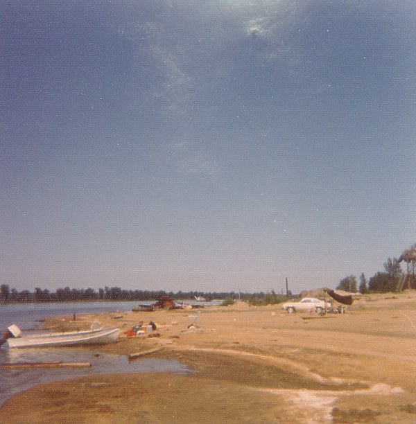
 Before the Carillon dam in 1962-64, 1ong sand beaches 20-30’ wide existed on the river side and the Island had 4 cottages. A fire in Ottawa on April 26, 1900 destroyed over 3000 buildings in Hull and Ottawa and some residents camped on the Island while their homes were being rebuilt. A portion of the Island was used as a dump in the 1950’s. The Region purchased the Islands in 1983 for preservation of the wetlands areas and for passive recreation uses. The area was designated a regionally significant area of natural and scientific interest by the Province in 1988 and is identified as Class one wetlands. The Friends of Petrie Island developed and operated a picnic area in August of 1998 with funds provided by the City of Cumberland.
Sources:
Trim Road Environmental assessment study – 1998.
Hurling Down the Pine: Hughson and Bond, Historical Society of Gatineau 1964
Archibald Petrie
by Paul LeFort (2003)
The Petrie Islands are named after Scotsman Captain Archibald Petrie of the Royal Navy (1783-1864).
During the War of 1812, Petrie was a purser on ships patrolling Lake Ontario. As many officers did at that time, he received land from the Crown upon leaving military service and settled in what would become the village of Cumberland, where he became a prominent merchant and politician.
Petrie once leased the islands that bear his name. He lived on farmland within view of the islands, along the Old Montreal Road. Petrie built the first road link between Bytown (now Ottawa) and Montreal. As were many such roads at the time, this was a toll road.
Archibald Petrie occupied several positions of importance in this locality, including councilman, reeve, Justice of the Peace and Member of the Upper Canada legislature. Archibald Petrie was married to Catherine Wilgress. The Petrie family, several members of which were prominent local residents, rests in Dale’s Cemetery, immediately to the east of the Cumberland Heritage Village Museum.

Since 1800
By Julia Fields
Weekly Journal Staff
Orleans Weekly Journal
5 September 1998
PROLOGUE: Petrie Islands — they’re a simple expanse of sandbars dipping into the Ottawa River just north of Cumberland’s Trim Road. Yet they’ve become the sight of developers’ dreams — the potential anchor for an interprovincial bridge between Masson-Angers and Cumberland, the possible.site of a marina complex and amphitheatre and the favoured spot for picnic parks. nature trails and a beach. In the months to come, the Weekly Journal will present a series of articles focusing on the issues surrounding the islands’ development. In the first of this series, Julia Fields examines Petrie Islands’ historical relevance within the community.
Jean-Louis Grandmaitre remembers Petrie Islands as his childhood paradise.
Every year, he and his two brothers would explore the forests, chasing after frogs and snakes. They would climb up the mountainous sand dunes. They would cool off in the swampy pools, which were then clear and unpolluted.
“We spent our summers here. We’d go boating and skiing. We always played on the sandbanks and the beach,” he reminisces.
Grandmaitre’s family owned the islands from 1955 until 1983. His grandfather Donat purchased them from a Cumberland farmer to open a sand extraction and gravel operation, which Jean-Louis now runs on the east side of the main island under a lease agreement with the Regional Municipality of Ottawa-Carleton.
The investment brought the Grãndmaitres good fortune, both in terms of a livelihood and fond memories of summers spent in the family’s private cottages.
Historically the 275 acres of islands provide the basic necessities of life. Villagers purchased half- or quarter-acre treed lots for firewood, remembers 72-year-old Allan Findlay, a longtime Cumberland resident.
In winter, people would haul away two-or three-foot thick ice blocks, which they would then store in ice houses for refrigeration, he adds.
And in 1943, John James Farmer and Gerard Bouthillier had the good fortune to secure exclusive hunting and trapping rights for the site.
After the Grandmaitres purchased the property in 1955, however, the east side of the main island (which is not protected wetlands) was used for more commercial purposes.
Although exact dates are unknown, Jean-Louis thinks the area around the island’s causeway was once a garbage dump for the City of Vanier. It is possible the waste is still buried there, he adds.
The sand extraction company has continued to operate successfully on the east side. The sand deposits (the best in Ottawa, according to Jean-Louis) are used for 1,001 other reasons, but most commonly for masonry. The business has five full-time employees and hires local independent truckers on demand.
In the last 25 years, the island has also taken on the reputation of being a recreational haven.
Visitors have flocked to the islands’ natural habitat for fishing and picnicking since the 1970s, says Grandmaitre — a practice his family had always encouraged.
And in the 1980s, after the Grandmaitres sold the islands to the region, thousands gathered there to take part in Winterlude activities, such as the Motorsport Regional Championship Race, where provincial racing champions would gun across the ice at speeds of more than 160 kilometres per hour. Fishing derbies, broomball tournaments, sleigh rides and cross-country skiing were also popular events.
This summer, more than 300 people per week descended on the island for recreational purposes, an interest Cumberland and regional government now hope to further develop with a marina, parks and nature trails.
To facilitate these plans, Grandmaitre’s lease to operate his sand extraction company will expire in 18 months. Although Grandmaitre is disappointed the 43-year-old company will either close or be forced to relocate, he is optimistic his family will still participate in the islands’ development.
“There’s talk of building a marina – maybe we’ll have a partnership in building the recreational aspect of the island,” he explains.
Whether or not the plans proceed with his involvement, Grandmaitre is adamant that they not interfere with the islands’ wild spirit.
“What would be worse is if people use the island so much it ruins its natural aspects. We’re all for progress, but at what cost?”
Petrie Island and abutting shoreline have always served the people of Cumberland in one way or another.
Petrie Islands appeared on maps as early as the 1800s, but the name was not officially recorded as Petrie Island until 1939 and then pluralized in 1962.
The site was named after Capt. Archibald Petrie, an influential politician who shaped the early development of Cumberland Township.
Capt. Petrie, who hailed from Scotland, —leased the islands from the Crown in 1834. His home was built on the adjacent farm lands (the present home of regional councillor Robert van den Ham).
The prominent resident, a retired purser in the Royal Navy, (captain is thought to be a military designation) was the area’s member of Parliament. He successfully procured £4,000 to build a road along the south bank of the Ottawa River from Lachine to Bytown, which opened up the country, enabling it to develop further.
Petrie also served a variety of other —political functions during his lifetime, including reeve, Cumberland councillor and justice of the peace.
The islands changed hands several times after 1915, although little information has been recorded. What is known, however, is that Cumberland residents used the land to
Grandmaitre Cottages
The Grandmaitre family is well known in the Eastview (Vanier) area of Ottawa. In 1962 Donat Grandmaitre purchased Petrie Island, intending to operate a sand extraction business, and at the same time have a vacation spot for the family.
You can click on the photos below to see a larger version.
  |
| They purchased a used Bailey bridge and in 1962 used it to create a permanent access to Petrie Island. This was replaced in the 1970’s with the causeway that is there now (2006). The bridge was used to carry sand trucks from the island. |
 |
 |
They built several family cottage on the north side of the island, facing the main Ottawa River channel. The one above is now the interpretive center for Friends of Petrie Island. Spring ice floes caused damage to the cottage.
 |
 |
The second cottage was located about 100 meters to the east of the first cottage, just west of the traffic circle in the parking lot. The photos below are dated 1962.
 |
 |
They also had access to the beach which was largely natural. It was also built up from sand that was extracted from the island.
Pierre and Yves Grandmaitre have many fond memories of summers spent at Petrie Island in the 1960’s. Even though the family sold the island to the Regional Municipality of Ottawa-Carleton in 1983, the Grandmaitre’s remain involved in the island. Yves operates the Petrie Island Bait and Tackle Shop, renting boats and ice fishing huts to local enthusiasts.
Sand Extraction
When the Donat Grandmaitre purchased Petrie Island in 1962, he intended to run a sand extraction business. Petrie Island is rich in sand that has been deposited there by the Ottawa River.
Click any photo to see a full screen version.
 |
 |
The aerial photo on the left, dated in 1962, shows the Bailey bridge that gave access to the sand on the island. A dragline was initially used to extract sand. A steel cable was stretched between towers, and a scoop was dragged along the sand. The scoop dumped the load into a pile where it could be loaded into trucks.
 |
 |
 |
 |
A sifting tower was used to sort the sand based on its granularity. The sand was sold as far away as the U.S. for projects such as golf courses.
 |
Click here to see a movie from the 1960’s, showing how the dragline operated on Petrie Island. It is in WMV format, and should play in Windows Media Player. |
 |
In the 1980’s, the Grandmaitres stopped using the dragline, and began using a dredge that extracted the sand from under the water. The whole bay to the east of the present beach area has been dredged to a depth of 60 feet. The photo above shows sand piles on what is now the public beach. The sand extraction business, which operated by leasing the island from RMOC, was halted in 2002 to make way for the development of the beach.
Bailey Bridge 1962

Sand Dredging 1966
There is Gold in the Ottawa
(Ottawa Citizen newspaper clipping dated Saturday July 9, 1966. No by-line. Photo credit Martin Timmerman)
A project that fascinates builders and others in this area is the unique operation by which the Eastview firm of Donat Graindrnaitre, Limited, sucks up sand from the bed of the Ottawa River.
Contrary to what one might expect, good quality sand for use in various forms of construction is a comparatively scarce commodity in this area.
It was the late Donal Grandmaitre, long-time Mayor of Eastview and father of that city’s present Mayor Gerard Grandrnaitre, who devised the unique method of taking sand from the river bottom.
In the late Twenties, Donat Grandmaitre became dissatisfied with having to haul sand, by horse-drawn vehicles, from pits miles away, and the sand-sucking operation was the answer.
At the outset a steel tower, mounted on a flat barge, carried the pumping equipment, and the sand was taken along stretches of the river to the east of the city, then carried by barge up to docks located west of Parliament Hill.
Today much more modern pumping devices are used, and the sand is cleaned and processed on Petrie Island, about 10 miles down-stream, which the Grandmaitre firm purchased in 1956. The island consists of some 300 acres.
Two years ago, $75,000 worth of machinery was bought for this purpose, and last year more than $50,000 worth of sand was sold by the firm.
The 35,000-ton annual output is considered top quality sand for fine cement and mortar work, and Gerard Grandmaitre, now head of the firm, says that the present demand far exceeds the supply. He believes that in the near future the sand pumping and processing operation will have to be done on a round-the-clock basis.
Mr Grandmaitre adds that engineers have estimated there is sufficient sand on the river bottom in this area to serve the city and district’s needs for at least 100 years.

RMOC Purchase 1983
In 1983, the Regional Municipality of Ottawa-Carleton purchased Petrie Island from the Grandmaitre family. At the time, the RMOC was a regional government that oversaw 11 municipalities that made up greater Ottawa. Petrie Island was in the then-Cumberland Township. Below are the minutes of the council meeting that eventually led to the purchase of Petrie Island by the RMOC.
Regional Council Report 45 — 2813 — July 13th, 1983.
The Executive Committee has considered Planning Committee Repbrt 14 (see pages 2816 to 2824 ) which transmits the recommendation of the Planning Committee on a proposal that the P~trie Islands be acquired as recreational land in the Ottawa River Corridor.
The Planning Committee, in its review and discussion of the staff report, has recommended:
“That the recommendation (by staff) to acquire Petrie Island be rejected.’ (See page 2822
Executive Committee Discussion
in the course of its review of the Planning Committee Report, the Executive Committee was further briefed by the Director of Property Services on information pertinent to the proposed acquisition.
Some of the considerations mentioned were:
— The purchase price considers the business value as well as the real—estate value of the property;
— The debenture arrangement is a preferred rate and provides to the Region a benefit of $157,000 over 5 years;
— The price is considered to be very reasonable and might be higher if referred to a land compensation board;
— There were no immediate plans to develop the area as recreational property; any decision as to how, where or if this should occur would take place at some future date;
— The acquisition of the property is being looked at mainly, in terms of long term potential rather than for immediate use.
The opinions of the Committee on the proposal were sharply divided. Some of the views expressing opposition were:
— It would be foolish to eliminate this major source of sand in view of the increasing shortage in this area of this material;
— The water quality has not been tested recently and the value of the island for beach and other water recreational activities is dubious;
— The Region should not be involved in active recreation programs and such activities should be left to the area municipalities or to other levels of government;
— The Region has much higher priorities for expenditures and cannot really afford to become involved, inasmuch as development costs subsequent to acquisition could be even more expensive;
Regional Council Report 45 — 2814 — July 13th, 1983.
Executive
— While the area may have future potential, it should be developed by others such as the Province or the Federal Government;
— The Region should be merely a facilitator to show others the potential for development.
Some of the opinions supporting the proposal were:
The area has potential for multiple uses and the Region has an obligation to play its part in the recreational field and to take the long term view;
— Over the long term, the land is extremely valuable and with imagination it has many possibilities for development;
— The overall conservation and river corridor policy has been virtually decimated and it is important that those areas still left in the program are acquired;
— Should the Region acquire the land, there are a variety of ways and methods whereby the property might be developed, and which could include other levels of government, such as the Province and Federal Government;
— The Island is being looked at immediately for conservation purposes and only latterly for possible development.
Further to the foregoing discussion the Committee dealt with two motions, as follows:
a) That the Regional Municipality acquire Petrie Island as specified in the staff recommendation.
LOST
M. Catterall, A.S. Haydon, G. Macoougall in favour (3 — 3 split vote)
b) That other levels of government be made aware of the potential of Petrie Island for recreational development and that they be urged to look at this property with a view to acquis it ion.
CARRIED
A.S. Haydon dissented
In light of the divided vote on the proposed acquisition, the Committee noted that a report would be referred to Regional Council, without a recommendation by the Executive Committee.
The Property Acquisition Form at page 2325 sets Out finance comments and budgetary information.
Regional Council Report 45 — 2815 — July 13th, 1983.
Executive
Executive Committee Recommendations
The Executive Committee, noting the advice of the Planning Committee, and because of the split vote:
1. has transmitted Planning Committee Report 14 to Council, without recomxnendation, and;
2. has recommended that the other levels of government be made aware of the potential of Petrie Island for cecreational development and that they be urged to look at this Property with a view to acquisition.
Councjllor Grandmaitre declared a conflict of interest on this item stating that there was a family involvement and/or ownership of the subject land. Councillor Grandmaitre did not taken part in any discussion of this item or on Motions 183 and 184.
Regional Council — 2614 — July 13th, 1983.
MOTION NO. 183
Moved by Councillor W.G. Mactougall,
Seconded by Councillor N. Smith,
Resolved that the Regional Municipality of Ottawa—Carleton, acquire Petrie Island (Item 1 of Executive Committee Report 45).
‘Carried’ (subject to reconsideration — see Motion 184 on page 2614) on a division of 14 Yeas to 12 Nays as follows:
YEAS: Councillors H. Smith, Bartlett, ‘haput, Dewar, Holmes, Kehoe, MactDouqall, N. Smith, Clark, Holzman, Lavtolette, Catterall, Denison and Hasenack 14
NAYS: Councillors Wytenourq, Gattney, Robert, Allen, Bellemare, Bouwers, Munro, Rywak, Barrett, Bird, Franklin and Hunter 12
MOTION NO. 184
Moved by Councillor R.A. Robert,
Seconded by Councillor D. Munro,
Resolved that Council consider a Motion to reconsider Motion 183
(Petrie Island). H
“Carried’ pursuant to section 58 of the rules of procedure on a division of 12 Yeas to 12 Nays as follows:
YEAS: Councillors Wytenburg, Gaffney, Robert, Allen, Bellemare, Bouwers, Munro, Rywak, Barrett, Bird, Franklin and Hunter 12
NAYS: Councillors Bartlett, Chaput, Cewar, Holmes, Kehoe, Macflouqall,
N. Smith, Clark, Laviolette, Catterall, Denison and Hasenack 12
Councillor Grandmaitre declared a conflict of interest on Motion 183 and 184 stating that there was a family involvement and/or ownership in the subject land. Councillor Crandmaitre did not take part in any discussion or vote on Motions 183 and 184.
Modern Times
Al Tweddle and Paul Le Fort (March 2002)
Petrie Island has been used as a hunting, fishing and trapping area since ancient times. The 20th century saw the continuation of those uses, along with the development of a sand extraction and summer recreation area.
In the summer of 1900, the Petrie Islands, along with the Duck and Kettle Islands, were used as a campground for some of the 8,300 residents of Ottawa displaced by the Great Fire, which destroyed 1,900 buildings and covered 440 acres in the downtown area. 1 John Dunning, from Cumberland Village, recalls on numerous occasions bringing his children to swim at Petrie Island during the 1930’s-1940’s, where a huge sand bar extended out into the river.
Petrie Island was officially named in 1939. It had previously been known by various names, including Snake Island, Leonard Island, Petrie Island and O’Connor Island.3 Current local usage is “Petrie Island” in the singular, but official gazetteers, rover charts and maps list the feature as “Petrie Islands”.
Archibald Petrie (1790-1864) was a prominent resident of Cumberland who served as Purser on HMS Princess Charlotte on the Great Lakes, during the war of 1812, and as Captain of the first regiment of Russell Militia during the 1837 Rebellion. He was also a member of the Legislative Assembly of the Province of Canada from 1844 to 1847. 4 He was a member of Cumberland Council from 1852 to 1864, serving as Reeve from 1852 to 1856.
In 1956, the islands were acquired by Donat Grandmaître and the present sand operation, run by a member of the Grandmaître family until its closing in 2003, was begun. A bridge and road to the island were constructed at this time. The operation originally used a dragline in the Ottawa River to collect the sand, but this no longer worked after the power dam was built at Carillon in 1964; the sand was extracted by suction from the river after that date by Gerard Grandmaître Ltd.
The present Bill Holland Trail extending westward from the picnic area was originally built as a road with 50 cottage lots; only four cottages were built and two other lots were sold but never developed, they and the existing home west of the picnic area are the only privately-held land on Petrie Island.
The original steel Bailey bridge to the island, with wooden planks, was replaced by a causeway in the sixties. Up until 1983 the road to Petrie island was locked at a gate just north of the old Service road, when the business was closed.
Hydro-Québec’s Carillon power dam raised the water levels by 1 to 1.5 m. This caused the 6 to 8 metre wide natural sand beach on the river side of the island to be reduced to a few metres and created much of today’s marshy areas and backwaters. Some of the downstream islands were inundated. Portions of the island beyond the causeway were used as a dump from the 1950s to the 1970s. 6
The Regional Municipality of Ottawa-Carleton purchased the island from the Grandmaître family in 1983, allowing the sand extraction to continue until September 1998. A further lease extension for this operation was granted until March 2002.
The Township of Cumberland held its Winter carnival “Icefest” at Petrie Island from 1985 to 1989, with car races, winter camping, ice fishing taking place each February.
Following is a summary of the various studies/reports produced over the last 20 years regarding the Petrie Island area.
In 1977, Alfred Dugal compiled an unpublished resource inventory that divided the islands into 6 vegetation/floral zones and listed 28 types of birds and various plant species. It suggested the Hackberry/Butternut/Bitternut Hickory woods is an unusual forest association in Ottawa Carleton and is of regional significance.
Cumberland Township conducted two Master Plan studies (Sesquaig and March,1983, and Robinson, July 1997) and a Facilities study (Tweddle et al, 1992). Those studies showed strong public and staff support for the preservation of the existing natural areas and the development of a municipal park on the eastern portion of the island (an area zoned “waterfront open space” in the Regional Plan).
In 1988, Cumberland produced a “Highway 17 North to Ottawa River” planning study that gave background information on Petrie Island and stated that there was a unique opportunity to put Ottawa River shore lands in public ownership.
Wildlife Habitat proposed building nature trails and a picnic area in 1989. The 2 Phase proposal provided for spending $85,000 and $125,000 on the project; regional government rejected the proposal due to liability concerns and recommended no development take place until the end of sand extraction in 1998.
In 1990, the Cumberland Business Sector North Study was produced, detailing land use and development policies for the area, and showing two potential marina sites.
Linda Dunn, a former Cumberland Councillor, used Petrie Island as a case study on the importance of wetlands to our natural ecosystems in November1992. She recommended that the area by preserved and only used for eco- recreational purposes.
In 1994, Cumberland prepared a draft bridge brochure which presented concepts for a bridge across Petrie Island from Trim Road to Angers, in Québec. The plan allowed for the incorporation of a rail as well as vehicle bridge and passed over Petrie Island and north shore wetlands on pilings, for a total length of 3 kilometres.
In the fall of 1996, a Regional Government planning amendment classified the Petrie Island area as Class 2 wetlands. A map showed Petrie Island and the shoreline west to Bilberry creek as wetlands. It left the current Friends of Petrie Island picnic area and sand extraction areas as waterfront open space, but the bay where extraction occurs showed as significant wetlands. The wetlands classification was originally proposed by L’Arrivée and Brown in 1987 and recommended as an area of natural and scientific interest by Brunton in 1995.
In 1996, Stoke evaluated the Petrie Island area in a private report for Regional Councillor Robert Vandenham, suggesting that the east bay (south extraction area) should not be classed as wetlands. This view differed from the Ontario Ministry of Natural Resources (MNR) position, which stated the area should eventually return to wetlands when the extraction stopped. It should be noted that the area directly downshore from the sand operation is shallow, wetland terrain.
The Cumberland Planning Department prepared a draft plan for the Petrie Island area that included trails, a picnic area, a beach area, boat launch and a 300-berth marina, but did not show any bridge locations.
In the fall of 1997 the Stuemers, a Fallingbrook family, left from Petrie Island on a trip around the world in their sail boat, Northern Magic. The Stuemer family returned in 2001 to a crowd of thousands who welcomed them home.
In April 1998, the Friends of Petrie Island stated their position on the future of Petrie Island which favoured the entire sand extraction area being left as beach and parkland to service the eastern portion of Ottawa-Carleton and questioned the construction of an interprovincial bridge and marina at this location.
In July 1998, a planning document prepared by Cumberland Planning staff listed Cumberland proposals and steps required to develop a bridge or marina on Petrie Island, along with RMOC staff comments.. The latter neither endorsed nor rejected the marina proposal.
In October 1998 the Friends of Petrie Island presented their report to Cumberland Council on the operation of a picnic area for the month of August and the results of over 500 responses to a questionnaire on Petrie Island.
The Regional Municipality of Ottawa-Carleton, in February 1999, presented the results of several studies on its interprovincial bridge in the National Capital Region. The consultants recommended the best location was the Cumberland-Masson-Angers corridor which suggested a bridge extending from Trim Road across Petrie Island was the best option. Costs were based on a one-km bridge, in contrast to the three-km bridge.
In April 1999 the Ottawa Field Naturalists’ Club published a list of flora and fauna, including unique and rare species to be found on Petrie Island, also expressing some of their concerns about development in the area.
In the fall of 1999, Friends of Petrie Island presented their report to Cumberland Council on the two- month operation of the picnic area and interpretive program, reporting that over 20,000 people had visited during the season.
In December of the same year, an inventory and trail plan for Petrie Island area was prepared by Dan Brunton along with Thacker Associates; it suggested trail and interpretive signs for the area and included an inventory of flora and fauna. A preliminary action plan was presented to Planning Board on January 24, 2000. A bibliography lists 67 papers, reports and documents that refer to the natural aspects of Petrie Island.
In May and June of 2000, after presentations from Friends Of Petrie Island, Queenswood Heights Community Association, and Regional Chair Mr Chiarelli, Cumberland Council voted four to one against a bridge at Petrie Island, preferring the Kettle Island or a site further east.
On October 3 the Friends of Petrie Island presented their report to Cumberland Council on a five month operation reporting over 33,000 visits over the season and requesting an expansion of the beach area eastward, which Council concurred with. 26
On October 30 the final interpretive trail plan was presented to Cumberland Planning Board.
On Tuesday, Oct 24 the Regional Planning and Environmental committee accepted a report on Petrie Island and recommended that the status quo be maintained with no expansion of the beach area based on water quality issues.
The municipal election of November 2000 elected representatives for the new City of Ottawa. Councillors elected from the Orleans area, Herb Kreling and Phil McNeely, supported the development of a beach at Petrie Island and opposed a bridge at that site.
In 2001 FOPI operated under the new City of Ottawa with the same mandate as in previous years; the fall report showed an attendance increase to 60,000 person- hours of use over the five month period.
In August of 2001 the Stuemers returned after four years to a civic reception at Petrie Island attended by thousands.
In December 2001 Baird and Associates presented the results of a beach study for the development of beaches along the Ottawa river shore, with a potential marina in the East bay. The projected cost of a Phase 1 beach was $2.5 million. Phase 2 costs for beach services and boat launch were $2.8 million and Phase 3 marina costs were over $16 million.
Photographer Jim Robertson worked on a slide show “Seasons in the Life of Petrie Island” for presentation to interested groups.
NOTES AND REFERENCES
- Unconfirmed verbal communication
- Cumberland Communique, July 1987
- Article by Kathleen O’Brien, Cumberland Historical Society
- Article by George A. MacKenzie, May-June 1994, p. 89, Ottawa Branch news, OGL
- Cumberland Communique, Feb 1986
- Verbal communication, J. L. Grandmaître, owner of sand operation
- Cumberland Communique, Feb issues, 1985-1989
- Petrie Island woods – resource inventory (Alfred Dugal) OFNC Sept. 1977 (Unpublished)
- Recreation Master Plan studies, 1982, 1983, 1987, Cumberland Township, Communique, Feb issues 1985 – 1989
- Highway 17 North to Ottawa River Planning study – Feb 1988, prepared for Cumberland Township – Haigis, MacNabb , DeLeuw Ltd
- Sept 1989 – Regional Planning document on Wildlife Habitat Canada proposal for Petrie Island
- Cumberland Business sector North – Planning study/Development plan, June 1990
- The importance of Wetlands to our natural ecosystems, Petrie Island, a case study, Linda Dunn, Nov 1992, Carleton University paper
- Orleans-Masson-Angers bridge study prepared for Cumberland by McNeely Engineering, 1994
- Fall 1996 – Provincially significant Wetland Policy includes Petrie Islands and area (schedule 15) of amendment 61 Official Plan 1988
- A comparison of the current wetland Boundary mapping for Petrie Island and Baie La Fontaine – Provincially significant Wetlands with Mapping produced using the Ontario Wetlands Evaluation system Southern manual, 3rd edition, 1993 – Robert W Stokes, Nov 1996
- 1997 Cumberland draft plan for Petrie Island prepared by Cumberland Planning staff
- Petrie Island background and position of Friends of Petrie Island, April 1998
- Petrie Island Master plan background and issue paper, Cumberland Planning Dept., July 1998
- Friends of Petrie Island report to Cumberland Council, October 1998
- Interprovincial Transportation in the National Capital, Economic study, Feb 1999, prepared for RMOC by Totten Sims Hubicki Associates
- The Petrie Islands: Naturally special, C. Hanrahan & S. Darbyshire, Trail and Landscape, vol 32, #2, Pl 59 – 73, April-June 1999
- Friends of Petrie Island report to Cumberland Council, October 1999
- Natural environment inventory and interpretive concepts – Petrie Islands study area, Cumberland, December 1999, Brunton
- Bridge presentations to Cumberland Council, May/June 2000 – FOPI, QHCA, RMOC
- Friends of Petrie Island report to Cumberland Council, Oct 2000
- Petrie Island, an interpretive trail plan, City of Cumberland, Oct 2000
- Petrie Island update to Regional Planning and Environment Committee, Oct 24,2000
29. Petrie Island report for 2001, October
- “Petrie Island Master Plan Review” was prepared by W.F. Baird and Associates Coastal engineers Ltd. Oct 2001
- A video interview with the Gerard Grandmaitre family was conducted by David Villeneuve and Al Tweddle for the Cumberland Historical Society
- A slide show “A Year in the Life of Petrie Island” was completed by Jim Robertson