Getting to Petrie Island
Petrie Island is located on the Ottawa River, in the eastern part of Ottawa, Ontario, Canada. It can be accessed by car, transit and by bike. More details below in regards to transit service and bike routes.
Petrie Island is accessed from Highway 174 (The Queensway) at Trim Road. If you are driving from downtown Ottawa, take Highway 417 east until “the split”. Keep left at the split onto 174, which is still a four-lane limited-access highway that leads to Orleans. Stay on the 174 until the first traffic light, which will be Trim Road, at which you should turn left. Head north. To the stop sign. Then turn left onto Jeanne D’Arc Blvd, and right onto Tweddle Road.
You can find the Nature Centre on the island, close to the cul-de-sac at the far north end of Trim Road. The Nature Centre is west of the parking lots, down the Bill Holland Trail (about 250 metres) just past the picnic area and children’s playground.
If you drive, there is parking on the island, although this overflows during peak days. You will have to pay for parking – details below. Please note City of Ottawa Bylaw Officers regularly check for parking permits, even on Sunday evenings.
Parking on Petrie Island
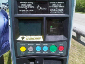
 There are 320 public parking spaces on Petrie Island, operated by the City of Ottawa. You must pay to park here. Rates are $2 for 5 hours, 07:00-18:00, 7 days a week. Your car must display the parking permit which you obtain from one of four Pay-and-Display stations. These machines accept coins and credit cards.
Parking is not permitted on the roadways. There is limited free parking near the causeway, mostly used by fishers.
These parking meters often cause complaints from patrons, because the machines are broken or due to the vigilance of the bylaw officers. The Friends of Petrie Island have nothing to do with the parking lots or the pay policy adopted by the City of Ottawa. Any complaints should be directed to the City of Ottawa by calling 311, or by contacting the Ottawa bylaw department.
Biking to Petrie
There are paved bike trails along North Service Road that lead to Petrie Island. Biking is permitted on Trim Road and along part of the Bill Holland Trail. You can also bike out along a paved area to the causeway on the beach. There is bike parking at the lifeguard station, at the Nature Centre and half way down the Bill Holland Trail, where we ask you to park your bikes and continue on foot.
Biking is not permitted on the smaller trails (Turtle Trail, River and Beaver Loop, Muskrat Trail, Basswood Trail and Sunrise Trail) or the west end of Bill Holland Trail. Do not go past the chained area with your bike. We ask that you please park your bicycle and enjoy a leisurely pace along these trails.
Bus Service
The nearest bus stops are the Trim Road park-and-ride lot and the North Service Road local bus stop. The 95 route runs every 15 minutes during the week and the local bus runs every hour. Some of these buses will have bicycle racks. From the bus stop it is an enjoyable 15 to 20 minute walk or a 5 to 7 minute bike ride to Petrie Island, down the hill and along the causeway with many views of the water and optional trails to take off the main road. Or see Route 139 below.
Summer Bus Service Route 139
Route 139 provides bus service from Place d’Orléans and Trim Park & Ride to Petrie Island. Service will operate weekends and holidays throughout the summer, every 30 minutes, between approximately 9 a.m. and 6:30 p.m. Schedule here.


