|
|
 |
| Frozen site archive of 2015/01/17. Visit www.petrieisland.org for current site. |
Petrie Island in Modern TimesAl Tweddle and Paul Le Fort (March 2002)
In the summer of 1900, the Petrie Islands, along with the Duck and Kettle Islands, were used as a campground for some of the 8,300 residents of Ottawa displaced by the Great Fire, which destroyed 1,900 buildings and covered 440 acres in the downtown area. 1 John Dunning, from Cumberland Village, recalls on numerous occasions bringing his children to swim at Petrie Island during the 1930's-1940's, where a huge sand bar extended out into the river. 2
Archibald Petrie (1790-1864) was a prominent resident of Cumberland who served as Purser on HMS Princess Charlotte on the Great Lakes, during the war of 1812, and as Captain of the first regiment of Russell Militia during the 1837 Rebellion. He was also a member of the Legislative Assembly of the Province of Canada from 1844 to 1847. 4 He was a member of Cumberland Council from 1852 to 1864, serving as Reeve from 1852 to 1856. 5 In 1956, the islands were acquired by Donat Grandmaître and the present sand operation, run by a member of the Grandmaître family until its closing in 2003, was begun. A bridge and road to the island were constructed at this time. The operation originally used a dragline in the Ottawa River to collect the sand, but this no longer worked after the power dam was built at Carillon in 1964; the sand was extracted by suction from the river after that date by Gerard Grandmaître Ltd.
The original steel Bailey bridge to the island, with wooden planks, was replaced by a causeway in the sixties. Up until 1983 the road to Petrie island was locked at a gate just north of the old Service road, when the business was closed. 6 Hydro-Québec’s Carillon power dam raised the water levels by 1 to 1.5 m. This caused the 6 to 8 metre wide natural sand beach on the river side of the island to be reduced to a few metres and created much of today’s marshy areas and backwaters. Some of the downstream islands were inundated. Portions of the island beyond the causeway were used as a dump from the 1950s to the 1970s. 6 The Regional Municipality of Ottawa-Carleton purchased the island from the Grandmaître family in 1983, allowing the sand extraction to continue until September 1998. A further lease extension for this operation was granted until March 2002. The Township of Cumberland held its Winter carnival “Icefest” at Petrie Island from 1985 to 1989, with car races, winter camping, ice fishing taking place each February.7 Following is a summary of the various studies/reports produced over the last 20 years regarding the Petrie Island area. In 1977, Alfred Dugal compiled an unpublished resource inventory that divided the islands into 6 vegetation/floral zones and listed 28 types of birds and various plant species. It suggested the Hackberry/Butternut/Bitternut Hickory woods is an unusual forest association in Ottawa Carleton and is of regional significance. 8 Cumberland Township conducted two Master Plan studies (Sesquaig and March,1983, and Robinson, July 1997) and a Facilities study (Tweddle et al, 1992). Those studies showed strong public and staff support for the preservation of the existing natural areas and the development of a municipal park on the eastern portion of the island (an area zoned “waterfront open space” in the Regional Plan).9 In 1988, Cumberland produced a “Highway 17 North to Ottawa River” planning study that gave background information on Petrie Island and stated that there was a unique opportunity to put Ottawa River shore lands in public ownership.10 Wildlife Habitat proposed building nature trails and a picnic area in 1989. The 2 Phase proposal provided for spending $85,000 and $125,000 on the project; regional government rejected the proposal due to liability concerns and recommended no development take place until the end of sand extraction in 1998. 11 In 1990, the Cumberland Business Sector North Study was produced, detailing land use and development policies for the area, and showing two potential marina sites. 12 Linda Dunn, a former Cumberland Councillor, used Petrie Island as a case study on the importance of wetlands to our natural ecosystems in November1992. She recommended that the area by preserved and only used for eco- recreational purposes. 13 In 1994, Cumberland prepared a draft bridge brochure which presented concepts for a bridge across Petrie Island from Trim Road to Angers, in Québec. The plan allowed for the incorporation of a rail as well as vehicle bridge and passed over Petrie Island and north shore wetlands on pilings, for a total length of 3 kilometres.14 In the fall of 1996, a Regional Government planning amendment classified the Petrie Island area as Class 2 wetlands. A map showed Petrie Island and the shoreline west to Bilberry creek as wetlands. It left the current Friends of Petrie Island picnic area and sand extraction areas as waterfront open space, but the bay where extraction occurs showed as significant wetlands. The wetlands classification was originally proposed by L’Arrivée and Brown in 1987 and recommended as an area of natural and scientific interest by Brunton in 1995. 15 In 1996, Stoke evaluated the Petrie Island area in a private report for Regional Councillor Robert Vandenham, suggesting that the east bay (south extraction area) should not be classed as wetlands. This view differed from the Ontario Ministry of Natural Resources (MNR) position, which stated the area should eventually return to wetlands when the extraction stopped. It should be noted that the area directly downshore from the sand operation is shallow, wetland terrain.16 The Cumberland Planning Department prepared a draft plan for the Petrie Island area that included trails, a picnic area, a beach area, boat launch and a 300-berth marina, but did not show any bridge locations.17
In April 1998, the Friends of Petrie Island stated their position on the future of Petrie Island which favoured the entire sand extraction area being left as beach and parkland to service the eastern portion of Ottawa-Carleton and questioned the construction of an interprovincial bridge and marina at this location. 18 In July 1998, a planning document prepared by Cumberland Planning staff listed Cumberland proposals and steps required to develop a bridge or marina on Petrie Island, along with RMOC staff comments.. The latter neither endorsed nor rejected the marina proposal. 19 In October 1998 the Friends of Petrie Island presented their report to Cumberland Council on the operation of a picnic area for the month of August and the results of over 500 responses to a questionnaire on Petrie Island. 20 The Regional Municipality of Ottawa-Carleton, in February 1999, presented the results of several studies on its interprovincial bridge in the National Capital Region. The consultants recommended the best location was the Cumberland-Masson-Angers corridor which suggested a bridge extending from Trim Road across Petrie Island was the best option. Costs were based on a one-km bridge, in contrast to the three-km bridge appearing in reference 9. 21 In April 1999 the Ottawa Field Naturalists’ Club published a list of flora and fauna, including unique and rare species to be found on Petrie Island, also expressing some of their concerns about development in the area. 22 In the fall of 1999, Friends of Petrie Island presented their report to Cumberland Council on the two- month operation of the picnic area and interpretive program, reporting that over 20,000 people had visited during the season.23 In December of the same year, an inventory and trail plan for Petrie Island area was prepared by Dan Brunton along with Thacker Associates; it suggested trail and interpretive signs for the area and included an inventory of flora and fauna. A preliminary action plan was presented to Planning Board on January 24, 2000. A bibliography lists 67 papers, reports and documents that refer to the natural aspects of Petrie Island. 24 In May and June of 2000, after presentations from Friends Of Petrie Island, Queenswood Heights Community Association, and Regional Chair Mr Chiarelli, Cumberland Council voted four to one against a bridge at Petrie Island, preferring the Kettle Island or a site further east.25 On October 3 the Friends of Petrie Island presented their report to Cumberland Council on a five month operation reporting over 33,000 visits over the season and requesting an expansion of the beach area eastward, which Council concurred with. 26 On October 30 the final interpretive trail plan was presented to Cumberland Planning Board.27 On Tuesday, Oct 24 the Regional Planning and Environmental committee accepted a report on Petrie Island and recommended that the status quo be maintained with no expansion of the beach area based on water quality issues. 28 The municipal election of November 2000 elected representatives for the new City of Ottawa. Councillors elected from the Orleans area, Herb Kreling and Phil McNeely, supported the development of a beach at Petrie Island and opposed a bridge at that site. In 2001 FOPI operated under the new City of Ottawa with the same mandate as in previous years; the fall report showed an attendance increase to 60,000 person- hours of use over the five month period. 29 In August of 2001 the Stuemers returned after four years to a civic reception at Petrie Island attended by thousands. In December Baird and Associates presented the results of a beach study for the development of beaches along the Ottawa river shore, with a potential marina in the East bay. The projected cost of a Phase 1 beach was $2.5 million. Phase 2 costs for beach services and boat launch were $2.8 million and Phase 3 marina costs were over $16 million.30 Photographer Jim Robertson worked on a slide show “Seasons in the Life of Petrie Island” for presentation to interested groups. 31
NOTES AND REFERENCES
1.
Unconfirmed verbal
communication
2.
Cumberland Communique,
July 1987
3.
Article by Kathleen O’Brien, Cumberland Historical
Society
4.
Article by George A. MacKenzie, May-June
1994, p. 89, Ottawa Branch news, OGL
5.
Cumberland Communique,
Feb 1986
6.
Verbal communication,
J. L. Grandmaître, owner of sand operation
7.
Cumberland Communique,
Feb issues, 1985-1989
8.
Petrie Island woods -
resource inventory (Alfred Dugal) OFNC Sept. 1977 (Unpublished)
9.
Recreation Master Plan
studies, 1982, 1983, 1987, Cumberland Township, Communique, Feb issues 1985 -
1989
10.
Highway 17 North to
Ottawa River Planning study - Feb 1988, prepared for Cumberland Township -
Haigis, MacNabb , DeLeuw Ltd
11.
Sept 1989 - Regional
Planning document on Wildlife Habitat Canada proposal for Petrie Island
12.
Cumberland Business
sector North - Planning study/Development plan, June 1990
13.
The importance of
Wetlands to our natural ecosystems, Petrie Island, a case study, Linda Dunn,
Nov 1992, Carleton University paper
14.
Orleans-Masson-Angers
bridge study prepared for Cumberland by McNeely Engineering, 1994
15.
Fall 1996 -
Provincially significant Wetland Policy includes Petrie Islands and area
(schedule 15) of amendment 61 Official Plan 1988
16.
A comparison of the
current wetland Boundary mapping for Petrie Island and Baie La Fontaine -
Provincially significant Wetlands with Mapping produced using the Ontario
Wetlands Evaluation system Southern manual, 3rd edition, 1993 -
Robert W Stokes, Nov 1996
17.
1997 Cumberland draft
plan for Petrie Island prepared by Cumberland Planning staff
18.
Petrie Island
background and position of Friends of Petrie Island, April 1998
19.
Petrie Island Master
plan background and issue paper, Cumberland Planning Dept., July 1998
20.
Friends of Petrie
Island report to Cumberland Council, October 1998
21.
Interprovincial
Transportation in the National Capital, Economic study, Feb 1999, prepared for
RMOC by Totten Sims Hubicki Associates
22.
The Petrie Islands:
Naturally special, C. Hanrahan & S. Darbyshire, Trail and Landscape, vol
32, #2, Pl 59 - 73, April-June 1999
23.
Friends of Petrie
Island report to Cumberland Council, October 1999
24.
Natural environment
inventory and interpretive concepts - Petrie Islands study area, Cumberland,
December 1999, Brunton
25.
Bridge presentations to
Cumberland Council, May/June 2000 - FOPI, QHCA, RMOC
26.
Friends of Petrie
Island report to Cumberland Council, Oct 2000
27.
Petrie Island, an
interpretive trail plan, City of Cumberland, Oct 2000
28.
Petrie Island update to
Regional Planning and Environment Committee, Oct 24,2000
29. Petrie Island report for 2001, October
29.
“Petrie
Island Master Plan Review” was prepared by W.F. Baird and Associates Coastal
engineers Ltd. Oct 2001
30.
A video interview with
the Gerard Grandmaitre family was conducted by David Villeneuve and Al Tweddle
for the Cumberland Historical Society
31.
A slide show “A Year in
the Life of Petrie Island” was completed by Jim Robertson
|
 Petrie Island has
been used as a hunting, fishing and trapping area since ancient times. The 20th century saw the
continuation of those uses, along with the development of a sand extraction and
summer recreation area.
Petrie Island has
been used as a hunting, fishing and trapping area since ancient times. The 20th century saw the
continuation of those uses, along with the development of a sand extraction and
summer recreation area.  Petrie Island was
officially named in 1939. It had previously been known by various names,
including Snake Island, Leonard Island,
Petrie Island and O’Connor Island.3 Current local usage is “Petrie Island” in the
singular, but official gazetteers, rover charts and maps list the feature as “Petrie
Islands”.
Petrie Island was
officially named in 1939. It had previously been known by various names,
including Snake Island, Leonard Island,
Petrie Island and O’Connor Island.3 Current local usage is “Petrie Island” in the
singular, but official gazetteers, rover charts and maps list the feature as “Petrie
Islands”.
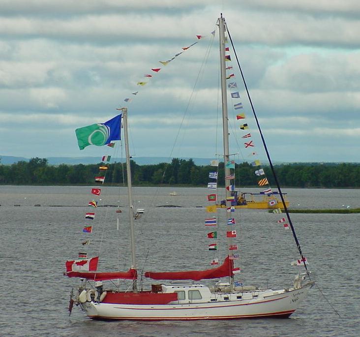 In the fall of
1997 the Stuemers, a Fallingbrook family,
left from Petrie Island on a trip around the world in their sail boat,
Northern Magic. The Stuemer family returned in 2001 to a crowd of
thousands who welcomed them home.
In the fall of
1997 the Stuemers, a Fallingbrook family,
left from Petrie Island on a trip around the world in their sail boat,
Northern Magic. The Stuemer family returned in 2001 to a crowd of
thousands who welcomed them home.