SURFACE WATER QUALITY PROGRAMME
OTTAWA RIVER 1992
Regional Municipality of Ottawa-Carleton
EXECUTIVE SUMMARY
September 1990, the Environmental Services Committee endorsed a report on jurisdictional issues with respect to surface water quality management. The report outlined the Regional Municipality of Ottawa- Carleton’s responsibilities in the areas of surface water monitoring on the rivers, and at the beaches, direct storm water outlets, storm water treatment facilities, and combined sewer overflows, as well as pollution source investigations.
Nineteen ninety-one (1991) was the first year of the programme undertaken to fulfil these responsibilities. The 1992 programme based activities on the 1991 programme and recommendations. Results of the 1992 programme provide the following comments:
Recommendations From the 1992 Programme
1) Reduce the number of river monitoring sites with emphasis on in depth monitoring (various depths and wider ranging parameter list). At a minimum sites should include the upstream Regional boundary, a site upstream of the Rideau/Gatineau confluences, a site downstream of these two rivers, and a site at the downstream Regional boundary. This would address the elevated bacterial levels in the downstream portion of the river, isolate inputs between river confluences, yet maintain a database from Regional boundaries upstream and downstream. It will denote other contaminants of importance (biological significance) which affect the health of the aquatic ecosystem.
2) Reduce the frequency of sampling at these sites to once a month over the course of the ice free period (representative of yearly variations).
3) Increase emphasis on site specific areas such as: Robert O. Pickard Environmental Centre, Watt’s Creek Sewage Treatment Plant, Britannia and Lemieux Island Filtration Plants, Carp River, Watt’s Creek, Green Creek, Graham, Stillwater, Pinecrest, and Bilberry Creeks. These sites should incorporate land use and site specific parameters. Monitoring of the Regional facilities provides data on Regional housekeeping practices (eg. back-flushing) which may impact the river ecosystem.
4) Outfall sampling should be reduced in frequency and number. The parameters should also be tailored to land use within the RMOC. Outfalls monitored should coincide with data sources such as the Wastewater Operational Review, and work done by the RMOC Industrial Waste group. Prioritization of outfalls to be monitored in 1993 will be based on bacteria levels that exceed 500 counts per 100 ml and the outfalls relationship to known studies and land use as indicated.
5) To truly reflect a Regional perspective and develop a baseline for the rural areas, sites should be selected on the Carp River, and Castor Rivers, and on Bear Brook to coordinate with the Conservation Authorities and to determine nutrient and pesticide levels for background for future years work. Boundary creek sites sampled in 1987 will form the basis for, and supplement site selection for 1993.
6) Investigative procedures should be re-evaluated in order to provide public relations assistance and to dovetail with the RMOC’s Industrial Waste group to provide a comprehensive data package.
7) Initiate biomonitoring or some form of biological assessment of selected areas to determine a complete impact analysis of outfalls on surface water quality and the resulting health of the system. Bioaccumulation studies indicate contaminants with impact potential and the true health of a system. Presence/absence of organisms also serve to indicate impacts on the aquatic ecosystem.
8) At this time flow monitoring of creeks is not recommended for determining the health of the Ottawa River. It may serve to provide loading information from a tributary to the river but the sources within the tributary drainage areas still have to be determined and abated. The Ottawa River appears to assimilate the inputs of the parameters currently monitored. Temporal and spatial trends for pH, alkalinity, bacteria, etc. have been similar 1989-1992 and remain little changed from historical studies. The cost to calibrate even the major inputs to the Ottawa could be prohibitive and impacts could be determined in more cost effective ways (eg. biological assessments reducing analytical costs). Increased investigative efforts on a site specific basis are recommended.
9) Public education addressing the complexities of dynamic aquatic systems and the realities of beach closures is important. Outfalls may be bacterial sources, but impacts may only be observed under conditions specific to a place, time, wind direction, etc. Continuous monitoring of a beach site for bacteria for water quality purposes is not recommended.
10) Increase cooperative site specific monitoring with the Wastewater Collection and Industrial Waste and Laboratory Services staff of the Region as in CSO monitoring for the Operational review; potential snow dump technologies and water quality impacts; and bacterial speciation from selected surface water quality sources
From the Technical Report, Part III, Section 5
5.0 FAR LOWER REACH (Hiawatha Park to Cumberland)
5.1 Character of the Reach
The Far Lower Reach includes Upper and Lower Duck Islands, formed from sediment from the Gatineau and Rideau rivers to the Ottawa River. Sand is mined from this reach just below Petrie Island. This section of the river is surrounded by a less urbanized area than the other reaches (with the exception perhaps of the Far Upper Reach).
5.2 River Monitoring Sites
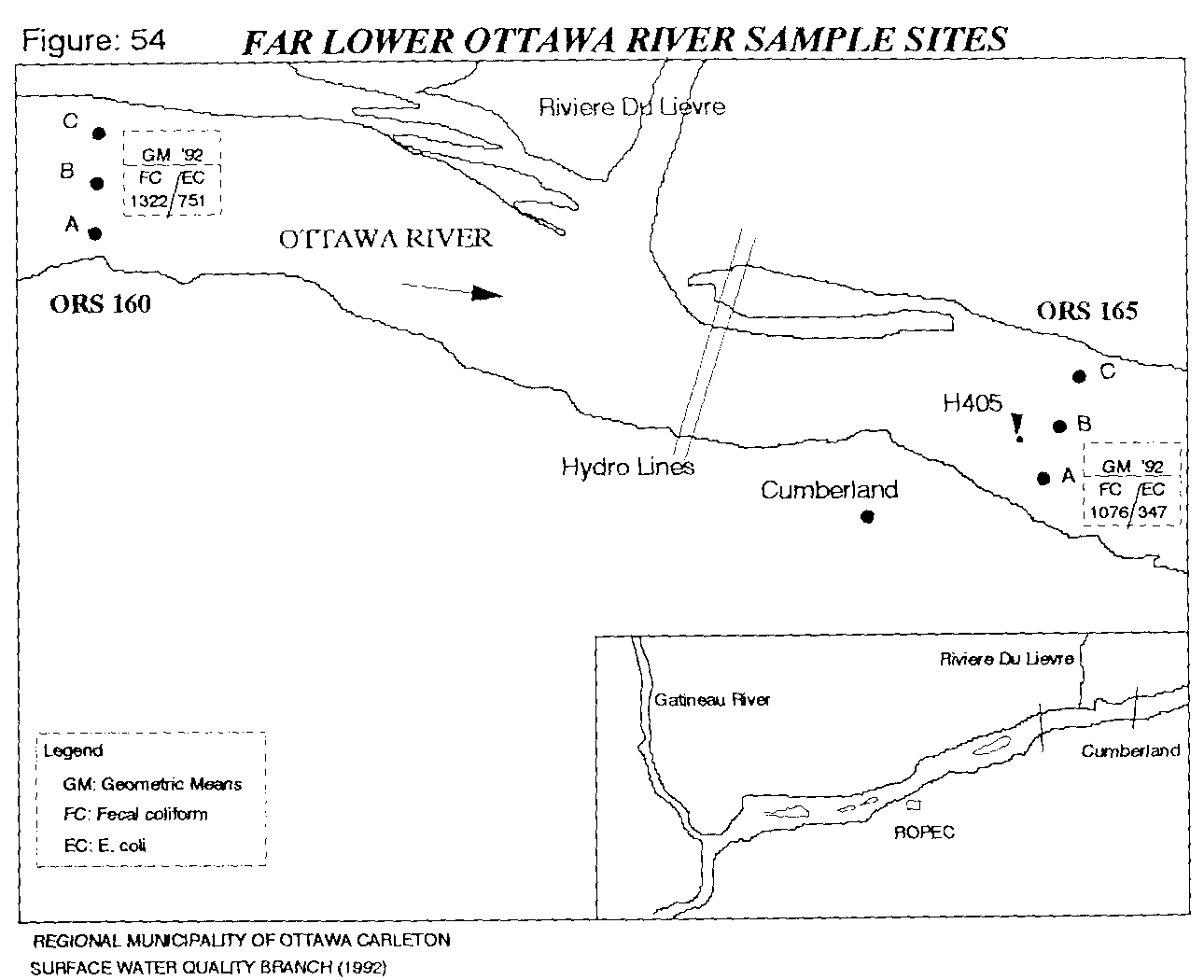
Figure 54 depicts the Far Lower Reach of the Ottawa River and the two river monitoring sites presently used. The sites are located upstream and downstream of the confluence of the Riviere du Lievre and Ottawa River. The water quality in the Far Lower Reach falls within the same ranges for each parameter as the other river reaches. The exception to this is high bacteria levels (Table 24, Appendix VII detected at the river sites.
Geometric means for fecal coliform are 1322 and 1076 counts respectively downstream in this reach (Figure 54).
5.3 Outfall Monitoring
Parameters also fall into a similar range of values for outfalls in this reach as they do in the others. Site specific investigation must be undertaken in order to address the individually high parameters (eg. Hiawatha Park Creek, ORE-37), conductivity, chlorides, sodium and potassium). Aluminum is above objectives at outfall Bilberry Creek (ORE-39) (Table 25, Figure 55). Detailed background information from land use records will assist in identifying the source. The following outfalls exceed the guidelines for recreational uses for fecal coliform:
Hiawatha Park Creek Bilberry Creek 30" Champlain St. 18" Willow Ave. 18" Teal/Cattail Way 66" Harlequin Crescent Taylor Creek Leonard/Cardinal Creek
ORE-37 ORE-39 ORE-40 ORE-41 ORE-43 ORE-44 ORE-45 ORE-46
Outfall levels are high and fewer in number in this reach than the Lower Reach, but river levels for bacteria are 2 to 3 times higher here than upstream. This suggests that sources of bacteria, other than outfalls, may be responsible. This question will be addressed by the 1993 programme.
5.4 Discussion and Summary
With the exception of the elevated fecal coliform levels in the Lower and Far Lower Reaches, there do not appear to be any river water quality impacts associated with outfalls. Localized sampling should provide more information. The bacterial sources must be continually high level inputs from the outfalls and incoming rivers, or bacterial activity within the sediments. Additional research into this area is advised for future work. Bilberry Creek, Taylor, Leonard, and Cardinal Creeks are under intense development pressure, and will be monitored in 1993.
6.0 Investigations/Complaints
Investigations may result from a baseline monitoring programme, from a filed complaint, or due to public perception of a situation (eg. closed beaches). Investigations follow procedures determined to isolate sources of problems in a relatively short time frame (ie. one day to a couple of days).
The objective of investigations has been to respond to high concentrations of bacteria at outfalls and creeks by attempting to isolate and identify sources of the problems. Priority parameters to date have been limited to bacteria and some nutrients. Identified pollution sources are reported back to the municipality in which the problem resides. The municipality is then responsible for some abatement or remedial action. Results of the investigations are reported via the Technical Pollution Abatement Committee (TPAC).
The Surface Water Quality Branch (SWQB) may do follow up monitoring to see if the situation has been corrected.