Petrie Island Master Plan
Background and Issue Paper
Cumberland Planning Department
July 1998
1.0 Introduction
2.0 Background
3.0 Demand and Justification
4.0 Current Policies
4.1 Regional Official Plan
4.2 Cumberland Official Plan
4.3 Provincial Policy
5,0 Developments Under Consideration
5.1 Passive Recreation Area
5.2 Active Recreation Area
5.3 Interprovincial Bridge
6.0 Work Required
6.1 Passive Recreation Area
6.2 Active Recreation Area
6.3 Interprovincial Bridge
7.0 Conclusion and Recommendation
7.1 Passive Recreation and Conservation Area
7.2 Active Park and Marina Area
7.3 Bridge
Figures
Petrie Island Master Plan, May 1997
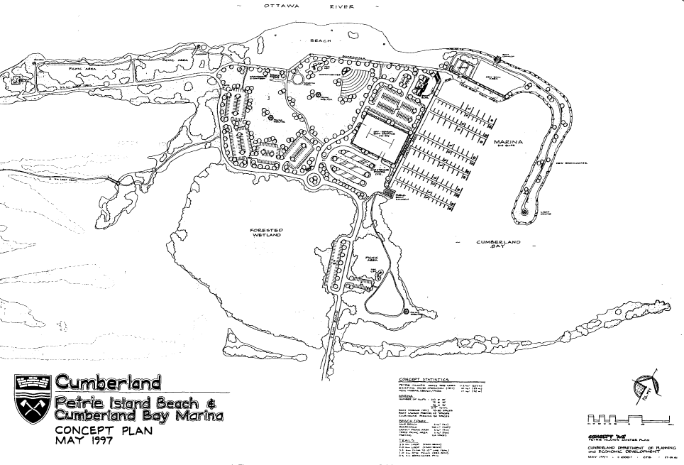
Petrie Island Beach and Cumberland Bay Marine, concept Plan, May 1997
Regional Official Plan, Schedule B, July 9,
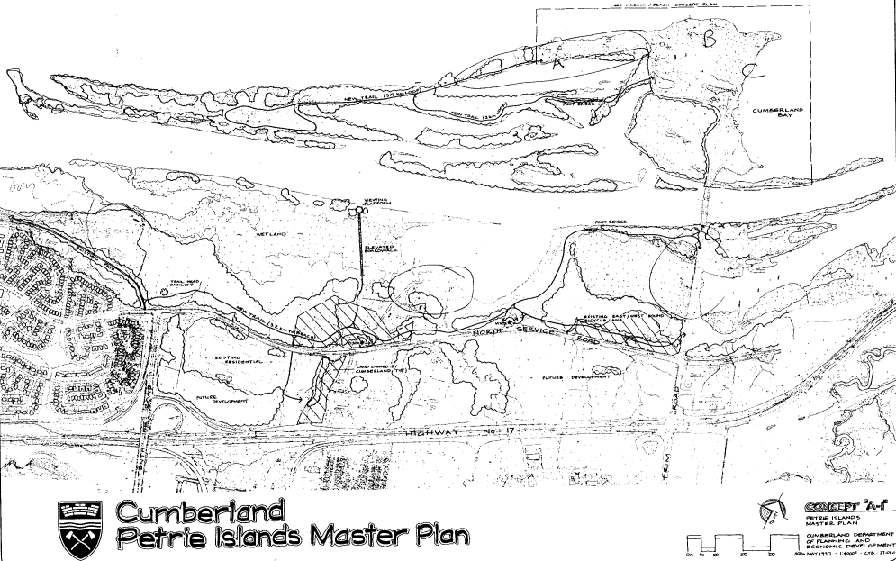
Petrie Island Master Plan, Study Area
Appendices
Also in the past few years, serious consideration has been given to the potential of a new bridge crossing the Ottawa River in a location at the end of Trim Road, crossing Petrie Island. This bridge location is the only crossing currently identified in the Regional Official Plan and it has garnered considerable support.
At this time there is a need to look at all the areas of interest as they relate to Petrie Island and the shoreline, identify the potential works, and establish a course of action for proceeding.
The natural environment portion of the island has been long identified by naturalists as an important area due to the presence of important flora and fauna, and fish spawning areas. Environmental inventories have been ongoing since the 1970’s. In 1988 the area was designated a Regionally Significant Area of Natural and Scientific Interest (ANSI) by the Provincial Ministry of Natural Resources. Since that time, with the classification by the Province of wetlands, the area has been identified as a Class 1 wetland (the highest rating in the Provincial system).
The sand extraction operation has been ongoing for almost 50 years. The land upon which the operation is located is owned by the Regional Municipality and is leased to the Grandmaitre’s for their operation, which is licensed by the Ministry of Natural Resources. The area which is used for the sand operation has been excluded from the wetland designation.
The island has been used publicly for many years. Long term activities in the area including winter ice fishing, summer fishing, public use of the beaches, and boat anchoring off shore. While most of these activities have occurred informally, the demand has been continual. In the area of the sand extraction operation, there currently exists a canoe and boat launch facility. The municipality has also made use of the island for the interfest celebrations which used to occur along the Ottawa River. XVhile the area has not been promoted, the attractiveness of this location has always drawn recreational users.
Cumberland’s recent initiative to develop the Ottawa River Business Park also strongly supports the demands for a unique environment and access to high quality recreation space. The potential businesses in this area will attract medium to high income professionals who are strongly motivated by lifestyle. This was confirmed by a presentation made by the president of J.J. Barnicke and Associates at the Capital East Forum. The development of the waterfront and a mariaa was viewed as a strong catalyst for bu" iness attra"tion in this area. Target marketing for the sales of the lands in the Ottawa River Business Park is specifically looking for an environmentally sensitive firm which is willing to take on a stewardship role for the lands along the Ottawa River.
The need for a marina in this location is displayed by the boats frequently anchoring off shore and constant requests for docking and anchoring facilities. Currently, the nearest facilities to the west are located in Ottawa at either Jacques Cartier Park or the Rockcliffe Yacht Club and to the east at Rockland. The Rockcliffe Yacht Club location is going to be closed and this club is looking to relocate their operation and they have expressed a desire to move to Petrie Island. This expression of interest illustrates the demand for facilities in this area.
Within the Wetland designation, development is restricted, This designation permits only specific types of uses. For example, open air recreational uses are permitted including accessory structures and buildings which do not adversely affect the natural characteristics of the environment.
Lands within the Waterfront Open Space designation are to be in public ownership and to be used for public recreation, environmental conservation, and education/interpretation uses. The designation permits open air recreation uses as well as "small scale recreational facilities, commercial activities, and institutional uses which contribute to, or are ancillary to, but do not detract from" the conservation and cultural values associated with the land and the waterways. Examples of other sites designated Waterfront Open Space include MacSkirruning Science School, the lands along the eastern and western parkways, and the Nepean Sailing Club and Andrew Haydon Park area.
The General Urban Area desimation along the North Service Road applies to only a small strip of table land. Within this area, a wider range of types of buildings are possible than could occur in the Wetland area.
The proximity of both the Waterfront Open Space and the General Urban Area lands to the wetland will result in the need to undertake a Wetland Impact Study for any developmerit within these areas. This study, which is scoped to suit the scale of development proposed, addresses the impacts any development will have on the adjacent wetland.
For!ar.ds adjaceat tc the Otta" - River, the plan foresees active recreational uses which require water access such as beaches, boat launching and boat mooring facilities provided that such uses do not significantly impact the conservation value of the area. Passive recreation such walking, hiking, bicycling and cross country skiing were also anticipated.
The area within the wetland as well as adjacent development is subject to the Provincial Policy Statement dealing with wetlands which has been enacted by the Province under the Planning Act. The policies of the Regional Official Plan are intended to reflect the Provincial policy however they are currently under appeal and will not likely be in effect until 1999. This does not preclude the municipality’s obligation to comply with the policies given that they are in force through legislation.
Many groups are considering the possibilities and options for the Petrie Island area. These groups include the Regional and municipal governments, the Friends of Petrie Island, economic development groups which see potential opportunities, environmenta1 and naturalists organizations, as well as provincial (Ontario and Quebec) governments.
The development options can be broken down into three broad categories:
1. Passive recreation and conservation space encompassing the wetland and natural areas
2. Active recreation space including possibilities for a beach, marina with associated facilities, as well as other active uses, and
Each of these broad categories includes its own interest groups, work programs, and government reviews and approvals. For discussion each area will be described independently however it is recognized that overlap exists between all the initiatives. Figure 4 illustrates the physical areas generally associated with each of these areas of consideration.
Given the environmental sensitivity of this area, and the requirement to obtain approval from senior levels of government for works on site, a master plan for this area must be prepared which takes into account the environmental issues and addresses the intensity of use which is appropriate. The preparation of a master plan should include the expertise of a designer with experience in park design and an environmental planner with expertise in biology and impact analysis.
It is proposed that the preliminary design work be undertaken using in house expertise of both the municipality and the Region. The Region has an environmental planner and Cumberland has a design planner. These individuals should develop a draft master plan based upon the environmental considerations of the site. This plan should then be reviewed by the public including the Friends of Petrie Island.
Given the scale of the proposed activity, and the fact that there would be no Planning Act applications (e.g. construction of major buildings) the Regional Official Plan may not require a full site Wetland Impact Study for passive recreation uses. Nonetheless, the Region have indicated that all work should be completed in a fashion which is accountable similar to the Wetland Impact Study. External review of the proposed plans by the Rideau Valley Conservation Authority will likely be required.
After the preparation of the final master plan, an implementation program will be prepared. The Friends of Petrie Island have been actively involved on the site already undertaking clean-up operations. It would be expected that this group would take an active role in the implementation of much of the master plan.
Ottawa-Carleton
Wetland Impact Study - Any development adjacent to the wetland will require a detailed environmental impact study to demonstrate "no negative impact on the natural features or on the ecological functions". This study will require approval by the Region, RVCA, and possibly the Ministry of Natural Resources.
Provincial Ministry of Environment
Environmental Assessment - Any municipal project with a total cost in excess of $3.5 million dollars is subject to an Environmental Assessment under the Environmental Assessment Act. It is unknown at this time whether this project is sufficiently large to fall into this range. For purposes of discussions, this project will be assumed not to be subject to an Environmental Assessment.
If an Environmental Assessment were to be required, it would be necessary to start the project with a Need and Justification Study which would look at whether a marina is needed at this location. Alternatives for a marina would have to be considered. As part of evaluating alternatives, studies would be required looking at environmental cooseaints, archeological conditions, cultural and heritage landscapes, geotechnical considerations, transportation impacts, property impacts, etc. This process is exceedingly onerous and time consuming.
Ministry of Environment Review of Marine Construction Projects - For projects not subject to an EA, the Minister applies Guideline B-1 to the review of projects. This requires looking at the short and long-terms effects of the construction on the aquatic environment including erosion, sedimentation, impacts on ground and surface water quality and quantity as well as impacts on the watercourse ecosystem. Mitigation measures will be considered.
Federal - Department of Fisheries and Oceans
Under Section 35(2) of the Fisheries Act, the Department of Fisheries and Oceans is responsible for reviewing proposals which will have an impact on fish. A potential marina on Petrie Island would be subject to this review. The objective of DFO is to achieve "no net loss" of habitat. This means that the Department may provide authorization to do work which impacts fish habitat subject to approved mitigation measures and the creation of additional habitat elsewhere. In order to obtain this authorization, considerable study must be done on the status of the existing fish habitat, determining what impacts will occur, and identifying acceptable mitigation measures and compensation.
Federal - Canadian Coast Guard
Any work in a navigable water requires approval through the Navigable Waters Protection Program under the Canadian Environmental Assessment Act (CEAA). The Ministry of Transport has been delegated authority to deal with issuing Formal Approval. The scale of the project will be evaluated to determine whether Formal Approval is required however guidelines indicate that marina projects and breakwaters are generally subject to this process. The process involves submitting the detailed plans accompanied by the necessary environmental assessment. The nature of environmental assessment required is determined by the Canadian Coast Guard upon receipt of a formal application. Environmental information should be enough to satisfy both the federal and provincial Environmental Assessment legislation. Obtaining Formal Approval also involves a process of public notification in 2 local newspaper and the Canada Gazette. An important consideration in obtaining Formal Approval is that the work must be commenced within 6 months and be completed within 3 years.
The possibility of an interprovincial bridge in the 1ocation of Petrie Island is currently being pursued with great interest. Both Regional and local governments are involved in this process. The Region are taking steps towards preparing the Terms of Reference for an Environmental Assessment which will look at the bridge issue. Many of the approvals mentioned earlier for a marina also apply to a bridge. The following is a list of key approval required (not including Quebec approvals).
Federal:- Department of Fisheries and Oceans - Canadian Coast Guard Formal Approval
Provincial - Full Environmental Assessment under the Environmental Assessment Act
Regional - Amendments to the Regional Official Plan to complete the road network - Impact Analysis on Wetlands
6.1 Passive Recreation Area
A master plan for the location of nature trails and related facilities should be prepared jointly between Cumberland’s designer and the Region’s Environmental Planner to ensure that trails and future developments do not negatively impact the environment. A preliminary meeting to initiate this work has already occurred. This concept should also determine the location and extent of other recreational facilities which will be possible given the environmental constraints. It is anticipated that this work can be done over the summer of 1998. If additional expertise is required concerning specific environmental issues, assistance should be retained to deal with the specific issues. If development beyond pathways and strictly passive uses are foreseen, an evaluation by an external environmental biologist will likely be necessary to ensure that there is no impact on the wetlands and sensitive environmental features.
Approval of the master plan will be required by both the Regional and Cumberland Planning Committees and Councils. It is recommended that as with other planning studies, Planning Committee take the lead role in reviewing and commenting on the plan with the ultimate plan being recommended to Council for approval. While the Planning Department will take the lead in the preparation of the plan, the Parks and Recreation Department should be actively involved in reviewing and commenting on the plan. This will include a review by the Parks Committee.
The process of preparing the overall island concept should include a public participation process including both the general public and the Friends of Petrie Island. It is recommended that the concept plan be presented publicly at an open house, providing an opportunity for comments. These comments would be integrated in the recommended plan prior to final presentation to Planning Committee.
Review of the plan by the Ministry of Natural Resources and/or the Rideau Valley Conservation Authority may be required. The need for this review will be confirmed by the Region in co- operation with these agencies. This review will definitely be required if the development is significant enough to require an independent environmental evaluation. The Rideau Valley Conservation Authority act on behalf of the Region in evaluating Wetland Impact Statements. As a result the Region will be responsible for determining the need for this evaluation.
The master plan as approved should include an implementation strategy. Of particular interest will be the preparation of a short and long term development scenario for the island. The implementation plan should also address the roles of the municipality, the Region, and the public (ie. Friends of Peuie Island) in undermicing the necessary works.
At this time there are many individuals who are actively interested in proceeding to develop trails on the island. The first stage of implementation should look at what can (and should) be done in the short term (ie. 1999). Given the degree of uncertainty with the development of the balance of the island, in particular the bridge, the short term plan should include works which will not be impacted by the bridge development or which can be adjusted with very little effort. It is expected that a short term plan could look at pathways, a picnic area, and perhaps an interim parking area in the vicinity of the access to the sand extraction operation. Upgrading of the access road may also be necessary to provide safe vehicle and pedestrian access to the island.
The longer term master plan should consider the ultimate development of the passive area. This may include additional facilities, buildings (such as bathrooms), and a permanent parking area. This work should not be undertaken until the final plans for the bridge and the marina complex are resolved.
6.2 Active Recreation Area
As discussed in the previous section concerning the Active area (particularly the marina), the level of study and government approval must be determined prior to initiating work. The first step should be to retain a consultant to prepare a detailed terms of reference and work program which outlines all the specific studies and information required to obtain approval. These terms of reference must be agreed to by the various agencies to ensure buy-in to the work being done towards obtaining approval. This first step should be done in 1998. The Terms of Reference will establish:
The Terms of Reference for the overall project should be reviewed by both Regional and Cumberland staff and obtain Council approval in both instances. These Terms, sirrJIar to the discussion in the previous section dealing with the passive development, should also be subject to public scrutiny and therefore they should be presented for public comment. This public review could be done through an open house process or a public advisory committee could be established which would represent the general public interest in this matter.
Once the Terms of Reference are approved, the actual master plan for the active facility should be initiated. A Request for Proposals would be made to undertake the works identified in the Terms of Reference. Firms would submit proposals which would be evaluated and ultimately a firm be retained, It is hoped that this process could occur in time to enable the funds for the studies to be budgeted in the 1999 budgets.
Whether this project requires a full Environmental Assessment under the Provincial Environmental Assessment Act or not, a process similar to the EA should be followed. A Steering Committee consisting of the Region and the municipality will be created to direct the project, with Cumberland and the consultants jointly taking on the project management of the work program. The public will be actively involved through a series of open houses. A Public Advisory Committee may also be created to provide public review and comments on alternatives as they are designed. The details of this process will be defined in the Terms of Reference.
The process of designing the active space including a marina and beach will involve numerous studies, such as:
Such studies will facilitate the design and wi11 be required to support the necessary approvals. It can be expected that the completion of the overall study and approval will take between one and two years. It will be important to look at the (iming of this work in conjunction with the work program for the InterProvincial Bridge Study. Final decisions relating to the marina cannot be made until decisions are made on the bridge. The two processes are hoped to come together for the preparation of one final plan.
As part of identifying the requirements for the active facilities, and in particular the marina, a study should be prepared which establishes the demand and economic viability for the marina facility, including an analysis of the number of slips, types of slips (sail, power, size), requirements for buildings including a club facility, restaurant, etc. This study is required to form the basis for the design of the facility. The preparation of the Terms of Reference for the overall study should also include the preparation of separate Terms of Reference for this market analysis.
6.3 Interprovincial Bridge
The Region are currently proceeding with the preparation of certain background studies relating to the potential bridge. The Region will ultimately be responsible for preparing the Terms of Reference for the Environmental Assessment relating to the potential bridge. The Regional process will be able to benefit from some of the work being undertaken for the active park and marina. It may happen that the Region obtains approval to proceed with the Environmental Assessment for the bridge and both studies are ongoing at one time. It would be most effective to design the two facilities at the same time, sharing information such as environmental inventories. Every effort should be made to facilitate shared design and information. Work being done for the active facilities must take into account a potential location for a bridge crossing and it is anticipated that the two processes will eventually dovetail to create an ultimate solution.
7.2 Active Park and Marina Area
Cumberland should immediately retain a consultant to prepare the Terms of Reference as described above. Funds for this work will be made available from the Planning Department approved budget. The preparation of the Terms of Reference should be completed by the end of this year and will be presented to Planning Committee and Council for approval. The Terms of Reference for a market study looking at the need and justification for the active facilities including a marina should also be prepared. A firm to undertake the work will be chosen from those who submit proposals and at that time the work program and the budget will be brought forward to Council for approval.
Cumberland should support the initiatives of the Region to proceed with the preparation of the terms of reference for the design and approval of the bridge. Before undertaking data collection, such as the environmental inventory, Cumberland should review the needs for the bridge study anu determine wiiether the data can be coiiected in such a fashion to be useful to both studies. Every effort to facilitate the sharing of information and joint planning should be supported.
Appendix A
4 June 1998 File: 40-97-0060
Mr. Ned Lathrop Chief Administrative Officer Township of Cumberland 100 Centrum Blvd. Orleans, Ontario K1E 3V8
Dear Mr. Lathrop
Re: Terms of Reference for Development Plan for Petire Island
Further to our discussions regarding the terms of reference for the development plan and future land uses for Petrie Island please find attached the Regional issues that I feel should be addressed by the consultants in preparing the terms of reference for the study. You will probably want to add some local concerns to be addressed in the study.
Give me a call if you wish to discuss this further.
Sincerely,
I
Pamela Sweet, MCIP, RPP
Director
Policy and Infastructure Planning Division
CC.
E. Aquilina, Office of the Chair N. Tunnacli ffe, P lanning and Development Approvals Department J. Shipman, Planning and Development Approvals Department
Terms of Reference for Petrie Island Development Plan
Background
The Regional Municipality of Ottawa-Carleton purchased Petrie Island in 1983 for two main reasons. Its location provided waterfront open space with potential for recreational development adjacent to a growing urban area and acquisition provided an opportunity to protect important natural features.
The Township of Cumberland has proposed that a development plan be prepared for Petrie Island. This paper outlines Regional interests that should be addressed in future plans for Petrie Island. These interests should be incorporated into the terms of reference for the development plan.
Regionat Official Plan Policies
There are three main policy areas in the Regional Official Plan that relate to Petrie Island: 1. Protection of the natural environment. Petrie Island in an important habitat for waterfowl, and rare plants. Most of the island is designated Significant Wetland. The property has been identified by the Ministry of Natural Resour"es as an Area of Natura! and Scientific Interest (ANSI). 2. Provision of open space and open air recreation. Part of the island is designated Waterfront Open Space. 3. Protection of the approaches to the Cumberland-Anger Ottawa River crossing (located at Petrie Island).
Official Plan policies that relate to Petrie Island are summarized below.
Provincially Siggificant Wetlands: Permitted Uses and Activities
Waterfront Open Space: Permitted Uses and Activities
The lands designated Waterfront Open Space are affected by the Adjacent Land policies for Signific’ant Wetlands South and East of the Canadian Shield. Policies for Adjacent Lands state that site alteration will only be permitted if it is demonstrated that the proposed development or site alteration will not have any negative impacts on the natural features or the ecological functions for which the area is identified as described in the wetlands evaluation undertaken by the Ministry of Natural Resources.
Cumberland-Angers Crossing
The Ofhcial Plan states that Council shaii actively participate with other levels of government to fina! ise the location of the next crossing of the Ottawa River outside of the Greenbelt. Pending an agreement on the location, Council shall protect the approaches to the Cumberland-Angers crossing. To facilitate a bridge in this location four studies are being proposed to be completed this summer. A Steering Committee of local mayors, the National Capitai Commission, the Communaute Urbaine de i’Qutaouais and the Region of Ottawa-Carleton has been constituted to explore interprovincial travel.
Qther Considerations
Part of the property is being leased to Roger Grandmaitre Ltd. for a sand extraction operation. The lease expires in September 1998. The Region will be extending the lease for another 18 months. Any plans for public usage of Petrie Island during that time period will have address any potential conflicts between the sand operation and public access to the property.
Alternative Land Uses Proposed for Petrie fsland
The Township of Cumberland has proposed that a development plan for Petrie Island be prepared in partnership with the Region. The Township of Cumberland is advocating the establishment of a marina, a park including a beach and picnic area, and nature trails on the property.
The Region supports the preparation of a development plan for Petrie Island in order to study proposed uses and make recommendations to Council on future uses .
Terms of Reference tor Study,
The terms o f reference for the development plan should address the following issues related to the proposed uses of the property.
Nature Trails and Picnic Area
Public Beach
Ottawa River Crossing
Marina
Sand Extraction Operation
Costs A Management
Timing
Appendix No. 2
Work Program
Passive Recreation and Conservation Area
| Time Period | Work Activity |
| Summer 1998 | Cumberland prepares preliminary concept plan with input from the Regional environmental planner |
| Fall 1998 | Circulate concept to agencies (ie. Region, MNR, RVCA) for review and comments |
| Region evaluate general environmental impacts and identify where additional impact analysis may be necessary | |
| Issue notices in the Communique soliciting comments on the proposed design of Petrie Island and advertising a public open house | |
| Nov./Dec. 1998 | Hold a public open house to
obtain comments on the proposed concept Winter 1998/1999 |
| Winter 1998/1999 | Revise concept based upon comments received from the public and agency circulation |
| Early 1999 | Wetland Impact Statement initiated where required to evaluate the impact of any works on the wetland. If inventory work is required, this will require the spring and potentially the summer and fall of 1999. |
| Spring 1999 | Identify interim works which could be done in 1999. This would be those works which do not require detailed Impact Assessment and which may be possible prior to finalization of the bridge and marina plans. |
| Summer/Fall 1999 | Submit Wetland Impact Statement for approval by the Region/RVCA |
| Fall 1999 | Finalize Master Plan |
| Present Master Plan to the public | |
| Late 1999 | Submit Master Plan to Cumberland and Regional Planning Committee and Council for approval. |
Appendix No. 3
List of Environmental References